File:Map of Ur III.svg
From ChaldeanWiki

Size of this preview: 350 × 400 pixels. Other resolution: 210 × 240 pixels.
Original file (SVG file, nominally 350 × 400 pixels, file size: 335 KB)
| Description |
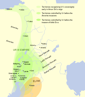
English: This map shows the extents of the Ur III Empire in Mesopotamia circa the 22nd century BCE.
Map oriented towards approximately northwest for some reason. based on Garelli, Paul: «El Imperio de Ur y su herencia», en El Próximo Oriente asiático. Barcelona: Labor 1974. ISBN 8433593102. Map from File:Ciudades del antiguo Oriente Medio.svg.Español: Mapa de la extensión del imperio de la Tercera Dinastía de Ur en Mesopotamia y el Oriente Próximo asiático hacia los siglos XXII y XXI adC |
| Date | (UTC) |
| Source | |
| Author |
|
| Other versions |
|


| This is a retouched picture, which means that it has been digitally altered from its original version. Modifications: English translation from Spanish original. The original can be viewed here: Mapa Tercera Dinastia de Ur.svg:
|
I, the copyright holder of this work, hereby publish it under the following licenses:
This file is licensed under the Creative Commons Attribution-Share Alike 3.0 Unported license.
- You are free:
- to share – to copy, distribute and transmit the work
- to remix – to adapt the work
- Under the following conditions:
- attribution – You must give appropriate credit, provide a link to the license, and indicate if changes were made. You may do so in any reasonable manner, but not in any way that suggests the licensor endorses you or your use.
- share alike – If you remix, transform, or build upon the material, you must distribute your contributions under the same or compatible license as the original.
You may select the license of your choice.
Original upload log
This image is a derivative work of the following images:
- File:Mapa_Tercera_Dinastia_de_Ur.svg licensed with Cc-by-sa-3.0, Cc-by-sa-3.0
- 2008-02-25T21:16:55Z Phirosiberia 350x400 (334081 Bytes) '
- 2008-02-25T21:12:35Z Phirosiberia 350x400 (334100 Bytes) '
- 2008-02-25T20:23:55Z Phirosiberia 400x250 (341331 Bytes) '
- 2008-02-25T19:31:47Z Phirosiberia 400x250 (348623 Bytes) {{inkscape}} {{Information |Description={{es|Mapa de la extensión del imperio de la Tercera Dinastía de Ur en Mesopotamia y el Oriente Próximo asiático hacia los siglos XXII y XXI adC}} |Source={{es|Trabajo propio, sobre
Uploaded with derivativeFX
File history
Click on a date/time to view the file as it appeared at that time.
| Date/Time | Thumbnail | Dimensions | User | Comment | |
|---|---|---|---|---|---|
| current | 11:39, 2 April 2024 | | 350 × 400 (335 KB) | Haziq Faruqi | File uploaded using svgtranslate tool (https://svgtranslate.toolforge.org/). Added translation for ms. |
File usage
The following 3 pages link to this file: