File:Ur III.svg


|
This SVG file contains embedded text that can be translated into your language, using any capable SVG editor, text editor or the SVG Translate tool. For more information see: About translating SVG files. |
| Description |
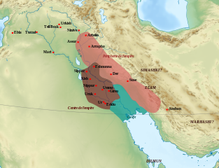
English: Approximate extension of the empire of the Third Dynasty of Ur (2112-2004 BC according to the middle chronology), with the center/periphery organization of Shulgi's reign (2093-2047 BC). Français : Extension approximative de l'empire de la Troisième dynastie d'Ur (2112-2004 av. J-C. selon la chronologie moyenne). En foncé, le partie centrale de l'empire, et en clair la partie périphérique suivant les principes administratifs du règne de Shulgi (2093-2047 av. J.-C.).
Sources : Piotr Steinkeller, « The Administrative and Economic Organization of the Ur III State: The Core and the Periphery », McGuire Gibson et Robert D. Biggs (dir.), The Organization of Power: Aspects of Bureaucracy in the ancient Near East, Chicago, 1991, p. 31 ; Walther Sallaberger, « Ur III-Zeit », dans Mesopotamien: Akkade-Zeit und Ur III-Zeit, Fribourg et Göttingen, 1999, p. 257 ; Bertrand Lafont, « Ur, l'empire gestionnaire (2100-2000) », dans Bertrand Lafont, Aline Tenu, Philippe Clancier et Francis Joannès, Mésopotamie : De Gilgamesh à Artaban (3300-120 av. J.-C.), Paris, Belin, coll. « Mondes anciens », 2017, p.211 et 224. Nombreuses variations de l'extension du centre et de la périphérie selon les auteurs (divergences : Eshnunna dans le centre ou la périphérie ; inclusion de Ninive et d'Urbilum/Arbèles dans les tributaires). |
| Date | (UTC) |
| Source | |
| Author |
|
| This is a retouched picture, which means that it has been digitally altered from its original version. Modifications: Ajout du royaume, des villes et régions.. The original can be viewed here: Middle East topographic map-blank.svg:
|
- You are free:
- to share – to copy, distribute and transmit the work
- to remix – to adapt the work
- Under the following conditions:
- attribution – You must give appropriate credit, provide a link to the license, and indicate if changes were made. You may do so in any reasonable manner, but not in any way that suggests the licensor endorses you or your use.
- share alike – If you remix, transform, or build upon the material, you must distribute your contributions under the same or compatible license as the original.

|
Permission is granted to copy, distribute and/or modify this document under the terms of the GNU Free Documentation License, Version 1.2 or any later version published by the Free Software Foundation; with no Invariant Sections, no Front-Cover Texts, and no Back-Cover Texts. A copy of the license is included in the section entitled GNU Free Documentation License. |
Original upload log
This image is a derivative work of the following images:
- File:Middle_East_topographic_map-blank.svg licensed with Cc-by-sa-3.0,2.5,2.0,1.0, GFDL
- 2010-11-03T17:52:56Z Sémhur 3097x1938 (10510751 Bytes) == {{int:filedesc}} == {{Information |Description={{Multilingual description |en= Blank physical map of the [[:en:Middle East|Middle East]] |fr= Carte physique vierge du [[:fr:Moyen-Orient|Moyen-Orient]]. }} |Source={{own}}.
Uploaded with derivativeFX
File history
Click on a date/time to view the file as it appeared at that time.
| Date/Time | Thumbnail | Dimensions | User | Comment | |
|---|---|---|---|---|---|
| current | 07:57, 10 May 2023 | | 1,252 × 959 (1.69 MB) | Zunkir | modification limites, suppression villes pour lisibilité |
File usage
The following 3 pages link to this file: